Airborne InfraredScanner SCAN-T
Purpose
The infrared scanner has been developed for airborne mapping of heat radiation from the earth's surface. Its high sensitivity of 0,05 ° C in an ambient background temperature 20 °C allows it to address a wide range of problems associated with:
Mapping and monitoring of various industrial and public utility infrastructures including
- power lines
- oil and gas pipelines
- heat water supplies
Monitoring of heat flow and thermal variations of natural and artificial ponds
Animal counting
Analysis of soil humidity
There are some examples of images:
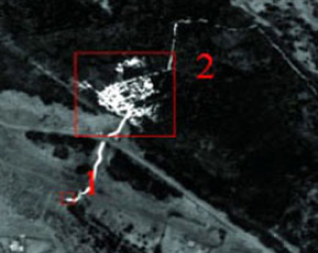
Industrial wastes leakage (1), and its impact on the forest (2). Smolensk region, 2006
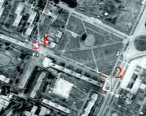
City heating system, Smolensk region, 2006. 1 - requires immediate repairing, 2 - increased heat emission
Features
Low weight (30 kg) and low power requirements (7 A, 27 V) of the scanner allow it to be installed in light helicopters and STOL airplanes with ease. Systems for example have been installed in Mi-2, Cessna-172D, Mi-8, An-2 with the sensor mount outside the fuselage and in P68 Observer 2 and Ka-26 with the sensor inside.
Thermal image consists of separate lines obtained with rotating mirror scanning system. Rotation frequency is 230 lines per second. Scanning process is performed with a sharp ray of 2,4'. The scanner uses a liquid nitrogen cooled high resolution sensor (CdHgTe) measuring radiation in the 8-14 μm range (far IR), cooling system is microcryogenic Integral-Stirling system. This provides a wide 120° field of view through a viewing aperture of 2,4'.
For pitch, yaw and roll corrections, the thermal imaging system has an integrated strapped-down attitude system consisting of three Fizoptika fiber optic gyroscopes and three Analog Devices ADXL-series accelerometers corrected by GPS. This system outputs yaw accuracy 2° and pitch and roll better then 1°. For altitude control, a radar altimeter such as the Terra TRA4500 or Smartmicro is provided.
In flight operations, an integrated flight planning, routing and navigation control system with a pilot indicator directs the pilot through the course of the survey. Scanner data is transferred using TCP/IP and recorded automatically with the attitude/altitude data. Software operates under Linux.
Post-processing integrates all data streams and automatically corrects image for attitude and altitude variations to produce high quality maps. Quality of the correction is illustrated with next figure:


Technical features
View angle: 120°
Scanning frequency: 230 lines per second, 3500 points in a line
Ray width: 2,4'
Wavelength range: 8-14 μm (far IR)
Sensitivity: 0,05 ° C for background temperature 20 °C
Detector: quantum (Cadmium Mercury Telluride) with microcryogenic Integral-Stirling cooling system
Resolution ability in 8-14 micron range (far IR): 0,03°С
Lossless real-time data compression
Data are are transferred through TCP/IP and recorded on the hard drive of an on-board laptop
Dimensions: 50х30х30 cm
Weight: 30 kg
Power requirements: 7 A from 27 V