Airborne Geophysical TechnologyEQUATOR
The EQUATOR system is intended to perform airborne geophysical surveys for the solution of a wide variety of geological and mapping problems. It includes:
airborne time-domain electromagnetic system (in addition, data can be represented in frequency domain)
airborne gamma-ray spectrometry (NaI(Tl) 48 l, energy resolution 8% for gamma-ray energy 662 keV)
software package for automatic data processing
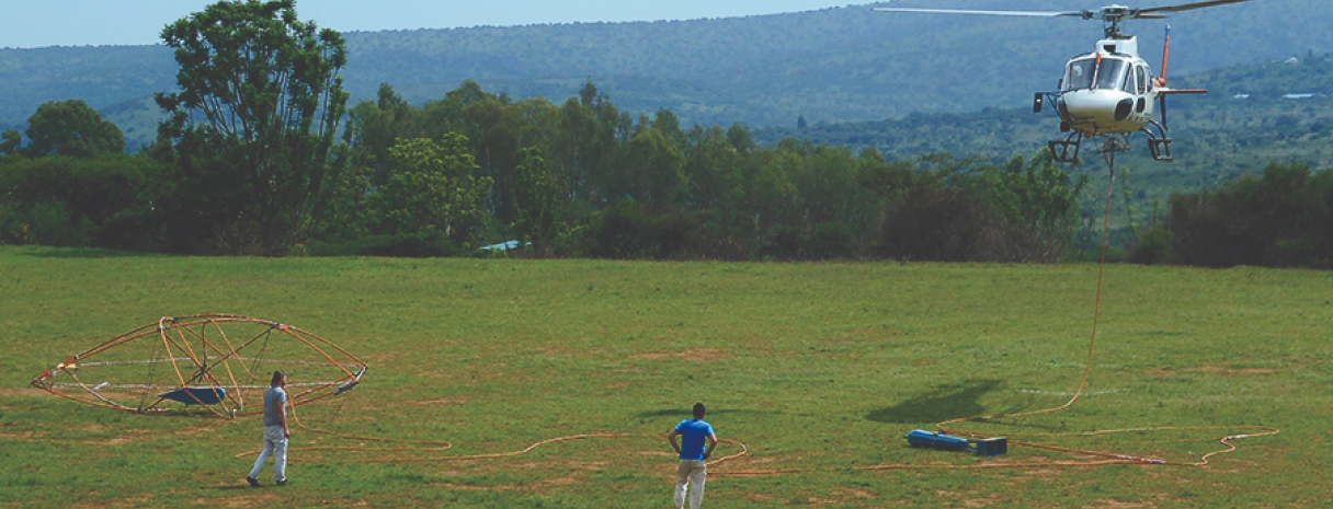
EQUATOR on the survey in Angola
EQUATOR Benefits
Record-Breaking Productivity
Thanks to the design of the towed platform, speed of an aircraft can vary in the wide range. For Eurocopter AS350 B3 average survey speed is 155 km/h, and maximum is 200 km/h. Small weight and good aerodynamics allow the use of the system even in the most difficult mountain conditions. The operations of control and adjusting take minimum time, and as a result a survey is conducted with a record-breaking productivity: more than 10 000 line kilometers per month.
High Sensitivity
The unique algorithms of signal processing suppress the noise by more than 30 times. And this makes it possible to combine high sensitivity of the system with rather small weight and compact dimensions.
Invariance To The Survey Conditions
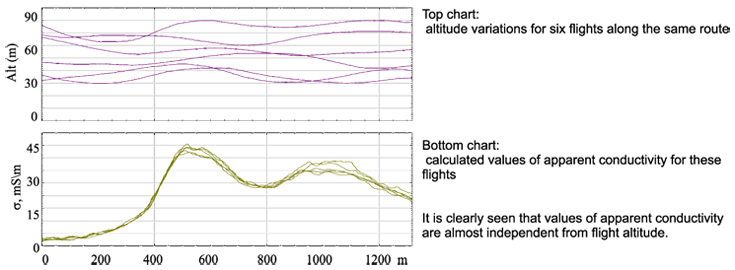
EQUATOR includes the system of monitoring of the geometry. It measures spatial coordinates of the helicopter, of the EM-transmitter and receiver, of the magnetic sensor, as well as flight altitude over relief, and other essential parameters. The accounting of all this information at data processing provides high quality and stability of received geophysical data.
Due to the application of our special algorithms of navigation, line distance for a high quality survey can be as small as 50m.
High Quality Of Airborne Magnetic Measurements
Sampling frequency of the EQUATOR magnetometer is 1000 Hz and its sensitivity is 0.6 pT/√Hz, that corresponds to the sensitivity of quantum CS-3 and CS-L sensors. This sample rate allows excluding the influence of the electromagnetic transmitter. Also it provides high-quality magnetic data in areas with high level of industrial noise (e.g. in the presence of power lines).
High Sensitivity Of Airborne Gamma-Ray Spectrometry
Since several lines of characteristic radiation from uranium and thorium are used the altitude of a flight can be increased, if necessary. The original procedure of free radon correction allows surveying in high humidity conditions (for example, during the rain season in Africa).
Maximum Completeness Of Collected Data
The completeness of the EQUATOR dataset gives to the geophysicists great opportunities of interpretation. Besides the traditional representation for transient electromagnetic method - as a set of values dB/dt (and even values of the field B(t)) - the geophysicist can analyze the response in a form traditional for frequency-domain systems (in-phase and quadrature response components at 14 frequencies from the range of the transmitter signal).

The example of EQUATOR data in time domain (two upper charts) and frequency domain (two bottom charts).
IP — in-phase, Q — quadrature response components. The arrows show local anomalies in high-conductive, resistive and medium-conductive zones.
High Exploration Efficiency
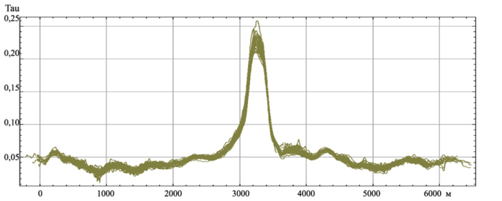
High spatial resolution of the EQUATOR system provided by a low placement of the transmitter and high rate of measurements (6.6 Hz) ensure detection of small low-contrast objects. The near-surface objects of 40 - 50 m in size with contrast of electrical resistance of 10-15% are reliably observed on apparent resistivity maps and are confirmed by accompanying magnetic anomalies.
Availability For All
High efficiency of the EQUATOR system and operation simplicity provide its efficiency even for small survey areas.

Technical Specifications
Electromagnetic measurements
Measurement method: Time-Domain and Frequency-Domain
Dipole moment (NIA): 50 000 - 100 000 A*m2
Base frequency: 77 Hz
Waveform: cut-off half-sine
Installation type: towed, with separated transmitter and receiver, the transmitter is below

Control of transmitter-receiver geometry: built-in positioning system; spatial accuracy is 15 cm, angular accuracy is 2 deg.
Output data in time-domain:14 off-time channels from 5 µs to 4,5 ms (X,Y,Z components)
Output data in frequency-domain: in-phase and quadrature components at 14 frequencies from 77 Hz to 16 000 Hz (X,Y,Z components)
Sampling frequency: 200 kHz, full-time
Output data frequency: 6,6 Hz
Total weight: 250 - 300 kg
Transmitter loop diameter: 7,5 - 11.5 m
Tow cable length: 70 m
Receiver placement: in a towed bird, at 40 m from the transmitter
Power consumption: 100 A, 27 V
Survey speed: 20-200 km/hr
Magnetic measurements
Magnetometer type: quantum
Sensor: Scintrex CS-3 or similar
Sensitivity: 0,6 pT/√Hz
Sample rate: 1000 Hz
Output rate of "distilled" data: 25Hz
Synchronization: by GPS
Sensor placement: in a bird together with the EM-field receiver