Airborne Low-Frequency Electromagnetic System EM-4H
The EM-4H installed on a light airplane or a helicopter is a cost effective conductivity mapping system well suited for
regional mineral exploration
groundwater resource evaluation
geological mapping
detailed survey of potential economic deposits
System Features
Due to low weight, low power requirements, and compact design of the system it can be installed on light helicopters and fixed-wing aircrafts with ease;
Nearly all functions are automated in order to make the EM-4H system very simple to operate. From our experience, it takes no more than 10-14 days to train technicians to conduct surveys confidently with EM-4H;
The EM-4H software, includes navigation and flight planning tools that automatically directs the aircraft to a start point, develops the optimum flight path and gives real time course corrections along the survey route to the pilot through a front mounted indicator. This software coupled with the GPS receiver data provides quality of location and flight height data good enough to conduct surveys with line spacing of 50 m or less;
Average productive speed of surveying is about 100 kilometers per hour;
EM-4H measures full response, i.e. inphase and quadrature components of the secondary field, with the accuracy about 1% for the averaging interval about 0.5 sec. This accuracy was achieved by the use of unique method of continuous transmitter-receiver geometry monitoring
;
;
This accuracy was achieved by the use of unique method of continuous transmitter-receiver geometry monitoring;
To obtain stable, nearly noise-free data modern signal processors, proprietary algorithms to remove aircraft influence, and effective mathematical methods of digital filtering are used.

Practical Use
Twelve EM-4H systems have been produced for Aerogeophisica, service company NF VSEGEI, diamond mining company ALROSA, and gold mining company Amur. Due to the achieved accuracy measured data can be converted to high-quality maps and profiles of apparent resistivity after short processing. These maps and profiles don't depend on a height and usually there is no need in any additional manual processing or filtering.

Boron-iron-ore deposit Zheleznii ridge in Chita region. There are apparent conductivity map combined with anomaly magnetic field and outlines of main tectonic structures (for frequency 2080 Hz) and conductivity depth images along four routes
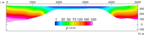
The profile of saline lake Tus in Khakassia. Specific resistance of the ground is about 100 Ohm-meters, resistance of the water is about 0.1 Ohm-meters.

System Specifications
Waveform Frequencies: (sinewave signal): 130, 520, 2080, 8320 Hz
Dipole moments: 20000, 10000, 4000, 2000 A•m2
Power requirements: 900 W (30 A for 27 V)
Interface: RS232 or Ethernet (TCP/IP)